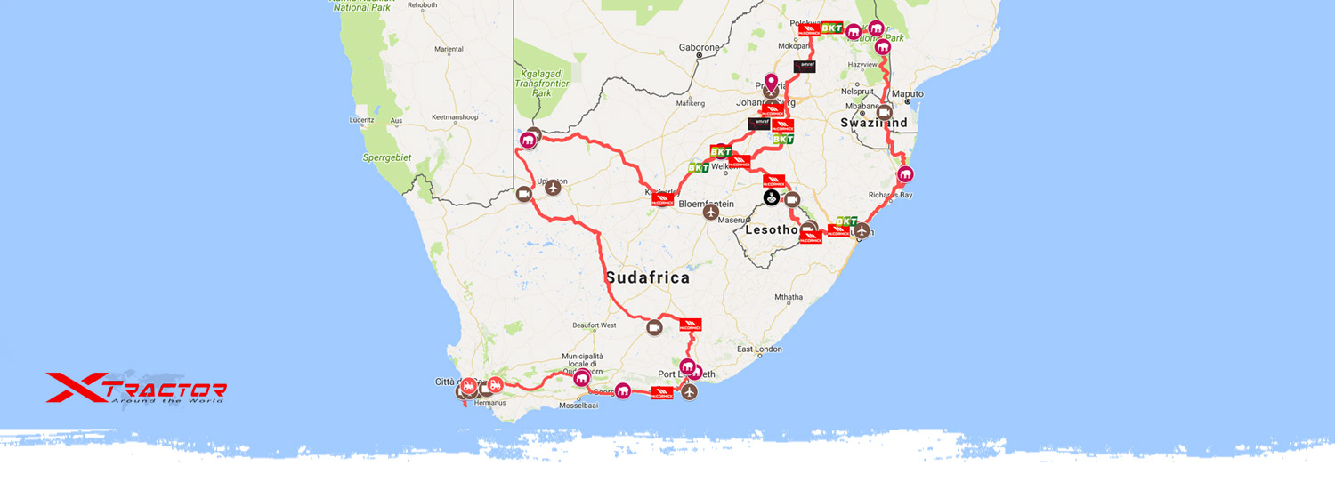
Starting from Cape Town at the beginning of April 2018, we will wind our slow and leisurely way among the vineyards of the Garden Route before heading straight inland across the vast semidesert interior, pushing deep into the Great Karoo and up among the sand dunes and boundless horizons of the Kalahari desert. Having reached as far to the North-West as possible, we will turn East, aiming for the summits of the small mountain kingdom of Lesotho (and perhaps a bit of snow). A steep descent down the imposing slopes of the Drakensberg chain will take us back to the sea, the Indian Ocean this time, for a quick tour of some of South Africa’s most celebrated nature parks, including world-renowned Kruger. Johannesburg and Pretoria will mark the finishing line for Xtractor’s second challenge.


Follow us on the interactive map and find out where the Xtractor’s team are right now live!

  • DAY 1, 2Apr: CAPE TOWN - DURBANVILLE

    The Xtractor expedition leaves Cape Town. The first European to set foot on the Cape, in 1497, was sea voyager Vasco da Gama, who then proceeded to successfully open up the sea route to the Indes. The area is a haven for many kinds of birds, as well as ostriches, antelopes, baboons, wildebeest and warthogs.

    1
  • DAY 2, 3Apr: DURBANVILLE - MONTAGU

    Press conference and official departure. From Stellenbosch we set off along the celebrated Wine Route, the scenic itinerary that winds its way through the Cape Winelands, the heartland of South Africa’s wine production. The European founding fathers of wine-making towns such as Stellenbosch, Paarl and Franschhoek were brilliant water engineers, whose skills were put to good use in turning the dry countryside into a green patchwork of vineyards. Today South African wines are renowned the world over.

    2
  • DAY 3, 4Apr: MONTAGU-OUDTSHOORN

    Heading down famous Route 62, we enjoy a pleasant drive among the vineyards, scenic mountain passes and pretty little colonial towns. Then we can expect an abrupt change of scenery as the road climbs down into the semiarid plains of Little Karoo. Oudtshoorn, our destination, used to be the world’s ostrich feather capital back in the second half of the 19th century, and still houses many ostrich farms to this day.

    3
  • DAY 4, 5Apr: OUDTSHOORN-KURLAND

    Today’s highlight, just out of Oudtshoorn, is magnificent Prince Albert’s Pass, a nearly 70 km long gravel track winding its way against dramatic landscape as we make a slow, thrilling descent from the Karoo highlands down to the sea. We will have some fun with our tractors up there! Next comes the scenic Garden Route, the world-renowned road that hugs the Indian ocean coast past celebrated sea-side resorts such as Mossel Bay, George, Wilderness, Knysna and Plettenberg Bay.

    4
  • DAY 5, 6Apr: KURLAND-HUMANSDORP

    In Kurland, just inland of Plettenberg Bay, we make a pit-stop at the free-roaming multi specie sanctuary for primates and thrilling rope-bridge deep in the forest. The Outeniqua and Tsitsikamma mountains overlooking the ocean offer some wonderful hikes and activities to trekkers, nature lovers, and birdwatchers. Sea dwellers include dolphins, sea lions and, between July and December, whales that come to breed in the sheltered bays. Today’s leg ends in Humansdorp.

    5
  • DAY 6, 7Apr: HUMANSDORP-ADDO ELEPHANT RESERVE

    First put on the map by Portuguese navigator Bartolomeu Dias in 1488, by the early 16th century Algoa Bay became a major supply station for Portuguese merchant vessels trading with Goa. Port Elizabeth, at the Western edge of the bay, is one of South Africa’s main seaports as well as home to the country’s motor vehicle industry. It boasts most vehicle assembly plants, and many other automotive-related companies. We take our leave of the ocean for a couple of weeks – Xtractor heads inland to the Addo Elephant Reserve.

    6
  • DAY 7, 8Apr: ADDO ELEPHANT RESERVE

    Once widespread in most of South Africa’s Southern part, elephants were gradually displaced by the European settlers’ drive to farm the land. When the first nucleus of the park was set up in 1931, thanks to the nascent wildlife protection movement, it counted just 11 specimens. Today the Greater Addo Elephant National Park, which includes the Elephant Reserve, is home to over 600 and is the only sanctuary in the world where all of the so-called Big 7 (i.e. elephant, rhino, lion, buffalo, leopard, whale and white shark) are to be found.

    7
  • DAY 8, 9Apr: ADDO-CRADOCK

    Xtractor’s next leg will take us to the far North-West of South Africa. Out of the Addo Elephant Reserve, we head towards Cradock, one of the Cape's chief centres of the wool industry which also produces beef, dairy and fruit. Of enormous importance to the economic development of Cradock was the construction of the Orange-Fish River Tunnel, a major irrigation project completed in 1975. This is also a major citrus growing region.

    8
  • DAY 9, 10Apr: CRADOCK–GRAAF REINET

    The Karoo is a vast semi-desert region raising gradually from the coast to cover most of South Africa’s interior tablelands. It’s mostly covered by savanna vegetation, dry-climate grass and bushes, succulents and characteristic red aloe. Nicknamed “the jewel of Karoo”, Graaf Reinet retains much of its old-time charm and a rich architectural legacy dating back to the late 18th century. Originally established as a trading post, it’s a flourishing market for agricultural produce, sheep and ostrich farming.

    9
  • DAY 10, 11Apr: GRAAF REINET-VICTORIA WEST

    Just out of Graaf Reinet, the breath-taking Valley of Desolation is highlighted by rock cliffs and delicate dolerite columns wrought over more than 100 million years by the combined efforts of volcanoes and erosion, raising 120 m high from the valley floor against the timeless backdrop of the Camdeboo plains. The scenery is increasingly arid and desolate as we push deeper towards the Upper Karoo. The old railway town of Victoria West has the feel of a frontier outpost.

    10
  • DAY 11, 12Apr: VICTORIA WEST – PRIESKA

    In Prieska, meaning “place of the lost sheep” in the Koranna language and an apt representation of its remoteness, there is a Boer War era fort built out of uncut tiger eye blocks. Here we first meet the mighty Orange, South Africa’s longest river rising from the Drakensberg Mountains in Lesotho, and flowing into the Atlantic Ocean. It is of paramount importance to the country’s economy as it provides precious water for irrigation and power generation.

    11
  • DAY 12, 13Apr: PRIESKA – KAKAMAS

    From Prieska onwards, settlements are few and far between. When special magistrate Maximillian Jackson arrived in 1868 on a punitive mission against the Griquas, though, there were none – he set up camp under the 500-to-600 year old Giant Camelthorn Tree, establishing what would be for a long time the remotest outpost in North-West Cape. Present-day Kenhardt is an agricultural and sheep farming centre set among green irrigated land. More desert travelling will lead us to the oasis of Kakamas.

    12
  • DAY 13, 14Apr: KAKAMAS

    A very short distance from Kakamas, the Augrabies Falls (sixth tallest on earth and aptly named “very noisy place” in Khoe-san language) originate as the Orange river plunges down a 200 m leap into an 18-km long gorge, carved out in the granite bedrock. Although there are many diamond fields to be found along the Orange, according to legend the very richest lies hidden under the roaring waters of the gorge. The falls are the centre-piece of a park featuring a varied animal population including giraffes, antelopes, zebras and several kinds of predators.

    13
  • DAY 14 e 15, 15-16Apr: KAKAMAS – LOCH MAREE

    North of Kakamas we are deep in the Kalahari, or “great thirst” in the Tswana language. A semi-desert region mostly belonging to Botswana, Eastern Namibia and North-Western South Africa, it’s a land of dunes stretching out as far as the eye can see, savanna and boundless horizons. Part of the immense African plateau, it lies at a median altitude of 900 m, and at 930,000 square km it is the largest desert on earth by surface. Vast and inhospitable, if not wholly uninhabitable, it’s still home to unique and vibrant flora and fauna - including South Africa’s iconic springbok.

    14 - 15
  • DAY 16 e 17, 17-18Apr: LOCH MAREE-HOTAZEL - KIMBERLEY

    The Kalahari has not always been a desert: there are huge subterranean water reserves beneath parts of it, perhaps the residues of ancient lakes, and evidence that the Kalahari Desert was once a much wetter place. The San people have lived here for 20,000 years, hunting wild game with bows and poison arrows and gathering edible plants, such as berries, melons and nuts, as well as insects. We drive along gravel tracks in a landscape of dunes and dust, empty except for a few isolated mining settlements.

    16 - 17
  • DAY 18, 19Apr: KIMBERLEY

    Kimberley is synonymous with diamonds ever since the De Beers company started exploiting its rich diamond fields, making it the largest city in the region and its founder Cecil Rhodes a tycoon. The area’s largest mine alone (170,000 sqm for a depth of 240 m) earned Mr Rhodes 3 tons of gems. Nicknamed “The Big Hole”, it was closed in 1914. Kimberley was the first city in South Africa (and the second in the world) to boast electric street lights, inaugurated in 1882.

    18
  • DAY 19, 20Apr: KIMBERLEY-HOOPSTAD

    From Kimberley our itinerary continues due East. The Bloemhof dam stands where the Vaal and Vet rivers meet, marking the border between the Free State and North-West provinces. The area surrounding the dam is protected under the Sandveld Nature Reserve, encompassing various savanna types. The huge Vaalharts irrigation project is one the world’s largest. Water from a diversion weir in the Vaal River, near Warrenton, flows through a 1,176km long network of canals, providing irrigation water to a total of 39,820ha scheduled land and industrial water to six towns

    19
  • DAY 20 e 21, 21-22Apr: HOOPSTAD-BOTHAVILLE-KROONSTAD

    The Free State, one of South Africa’s nine provinces, is hallmarked by green rolling hills, lush pasture and orchards. Hoopstad, Bothaville and Kroonstad are major agricultural towns and relevant maize producers. They date back to the migration of the Voortrekkers, the Boer settlers that abandoned the by then British-controlled Cape in the first half of the 19th century to push into the virgin lands across the Orange river, where they founded their own independent state – the Orange Free State.

    20 - 21
  • DAY 22 e 23, 23-24Apr: KROONSTAD-BETHLEHEM

    The Golden Gate Highlands National Park's most notable features are its golden, ochre, and orange-hued, deeply eroded sandstone cliffs and outcrops, as well as the numerous caves and shelters displaying San rock paintings. Although it’s more famous for the beauty of its landscape than for its wildlife, it is home to mongooses, eland, zebras, and over 100 bird species. Just as noteworthy is nearby Royal Natal National Park, which encompasses celebrated Tugela Falls, the second tallest on earth (912 mt).

    22 - 23
  • DAY 24, 25Apr: BETHLEHEM-BUTHA-BUTHE-OXBOW (Lesotho)

    Lesotho’s name translates as “the land of the Sotho-speaking people”, which is quite fitting as the Basotho, or Sotho, are the country’s main ethnic group. Lesotho is a landlocked kingdom completely surrounded by South Africa, and occupying the higher section of the Drakensberg mountain system. Actually, over 80% of the country lies above 1800 m, while the lowest point is 1400 m., making it the the only independent state in the world that lies entirely above 1000 m. The highest point is the peak of the Thabana Ntlenyana (3,482 m)

    24
  • DAY 25, 26Apr: OXBOW – MOKHOTLONG

    Afriski (3050 m) is Lesotho’s sole ski resort and one of only two in the whole of Southern Africa. A short distance to the South, the Letseng diamond mine is the highest in the world (3100 m), and famous for yielding huge gemstones. After climbing up and past a series of mountain passes all above 3200 m affording breath-taking views, the road plunges down to Mokhotlong (2556 m), Western Lesotho’s unassuming and remote main settlement.

    25
  • DAY 26, 27Apr: MOKHOTLONG - UNDERBERG

    The Drakensberg mountains mark the border between Lesotho and South Africa, peaking at the Thabana Ntlenyana (3.482 m), the Drakensberg’s highest summit as well as Southern Africa’s top altitude. The "Lesotho Mountains" are formed away from the Drakensberg escarpment by erosion gulleys which turn into deep valleys which contain tributaries of the Orange River. The large number of tributaries give the Lesotho Highlands a very rugged mountainous appearance. The legendary Sani Pass (2876 m) is sure to be one of the highlights of the Xtractor expedition.

    26
  • DAY 27 e 28, 28-29Apr: UNDERBERG-STEPMORE -PIETERMARITZBURG

    Back in South Africa, the road hugs the imposing slopes of the Drakensberg, which are increasingly popular with hikers and nature lovers who can enjoy several parks and nature reserves, while mountaineers can tackle a number of quite challenging climbs. Moving out of the mountains, the peaks and cliffs give way to softer relief. Green, rolling hills stretch out by the thousands all the way to the sea, affording some of the best landscapes in South Africa.

    27 - 28
  • DAY 29, 30Apr: PIETERMARITZBURG – DALTON

    Established in 1838 by the Voortrekkers, Pietermaritzburg was capital of a short-lived Boer republic called Natalia, which was incorporated in the Union of South Africa in 1910 as a province under the name of KwaZulu-Natal. It was here that Gandhi, evicted from a train for not being “white”, made the decision to stay on in South Africa and fight racial discrimination by nonviolent resistance. Extensive timber plantations and numerous citrus farms surround the city, thanks also to the Albert Falls Dam.

    29
  • DAY 30, 01May: DALTON – SAINT LUCIA

    From Dalton, an agricultural town whose economy is based on sugar cane farming, the itinerary winds its way against the spectacular backdrop of the Thousand Hills Valley, so called for the maze of rounded hills, cliffs and valleys flanking the banks of the Umgeni river as it flows down from its headwaters in the Drakensberg mountains to the Indian Ocean. In Saint Lucia, on the iSimangaliso doorstep, we have planned a two-day stop for some well deserved rest in a most beautiful setting!

    30
  • DAY 31-33, 02-04May: SAINT LUCIA- NTSHONGWE

    Third largest by size in South Africa, the iSimangaliso Wetland Park stretches over 280 km along the coast. Its name comes from the Zulu term meaning “wonder” or “miracle”, referring to the enthusiastic report of Zulu king Shaka’s envoy who first visited the place. The parks’ huge biodiversity, its unique ecosystems and natural beauty, all concentrated in a relatively small area, have earned it the status of UNESCO World Heritage site. iSimangaliso includes coral reef and sandy beaches, subtropical dune forests, savanna and wetlands which are home to a vast array of animal species, including elephants, African leopards, white and black rhinos, over 350 bird species, dolphins, turtles, whales and over a thousand Nile crocodiles, as well as the very rare latimeria, a fish so ancient it had been thought to be extinct.

    31 - 33
  • DAY 34, 05May: NTSHONGWE – HLANE NAT. PARK (Swaziland)

    Heading North away from the ocean, we enter Swaziland. The name of the small, landlocked kingdom means “land of the Swazi”, referring to the country’s main ethnic group who derive their name, in turn, from Mswati II, the 19th century king who expanded and unified the country. At no more than 200 km North to South and 130 km East to West, Swaziland is one of the smallest countries in Africa. The territory is mostly made up of a gently sloping plateau that dips slightly from West to East and raises again close to the Mozambique border.

    34
  • DAY 35, 06May: HLANE - KOMATIPOORT

    Ancient royal hunting ground of king Mswati II, the Hlane National Park (“desert” in Swazi language) stretches over a semi-arid plain dotted with acacia trees. It features an animal population including Transvaal lions, elephants, giraffes, white rhinos and the highest concentration of white vultures in Africa. Then, crossing the border once again, we are back in South Africa and looking forward to the next blockbuster – the Kruger.

    35
  • DAY 36-38, 07-09May: KOMATIPOORT – SATARA-LETABA (KRUGER NAT. PARK)

    The Kruger National Park is one of the largest game reserves in Africa. At 350 km North to South and 67 km East to West, it is South Africa’s biggest by size, and the best known. It belongs to the Kruger to Canyons Biosphere, an area designated by UNESCO as an International Man and Biosphere Reserve. First set up in 1898, it became the country’s first National park in 1926, and at present comprises 6 different ecosystems, each featuring different environment types ranging from thick acacia and sycamore woods to open savanna, for a total of over 1,900 plant species. The park is home to all the Big Five large mammals, counting an estimated 2,500 buffaloes, 1,000 leopards, 1,500 lions, 5,000 rhinos, and 12,000 elephants, in addition to zebras, cheetahs, giraffes, kudus, hippos, impalas, many kinds of antelopes, hyenas, swarthogs and wildebeest. Not to mention 500 different bird species (resident and migratory), 120 reptile species, 52 kinds of fish and 35 of amphibians. Three days won’t be enough to see it all, but it’s all we can afford.

    36 - 38
  • DAY 39, 10May: LETABA (KRUGER PARK) - TZANEEN

    Tzaneen, “Limpopo’s paradise”, is an agricultural town surrounded by lush, tropical countryside. Also dubbed “the country of the silver mist” because of the clouds often shrouding the mountains all around it, it farms about 40% of South Africa’s avocado production, 40% of its mangos, 20% of its bananas and 90% of its tomatoes. Pine and eucalyptus plantations are also a common sight.

    39
  • DAY 40-41, 11-12May: TZANEEN -POLOKWANE-EPHRAIM MOGALE

    Heading South again, towards the finish line, on 11 May we reach Ephraim Mogale, near Polokwane. Here, on 12 May, we will be privileged to visit a maternal health clinic operated by Amref, Africa’s largest health charity, and contribute to the community’s wellbeing by setting up a vegetable garden with our tractors, as a tangible sign of Xtractor’s visit.

    40 - 41
  • DAY 42-45, 13-16May: EPHRAIM MOGALE-BALFOUR-VILLIERS-BOTHAVILLE

    As the Xtractor expedition winds down to its close, we will have the honor and the pleasure of sharing our wonderful South African experience with a crowd of dedicated professionals taking part in South Africa’s foremost agricultural show. NAMPO, here we come!

    42 - 45
  • DAY 46, 17May: SEBOKENG

    We pay a visit to another Amref project. In Sebokeng we will have the opportunity of engaging with school kids and teachers who take part in the Healthy Lifestyle Project, which teaches children about exercising and how to conduct a healthy lifestyle in order to prevent non communicable diseases. We will talk with the kids, hand out Xtractor gadgets, and our tractors will be put to work laying out a football field for kids to play on, exercise and practice the activities they learn in the classroom.

    46
  • DAY 47-48, 18-19May: JOHANNESBURG

    Arguably the continent’s, as well as the country’s, financial and economic hub, Johannesburg is South Africa’s largest city by population (8 mln including the suburbs). Also known as Jo’burg and Jozi, to the Zulus it’s eGoli, “the gold place” , referring to both the gold fields that made it rich and its present-day economic might. Among the sights feature the Houghton district, where Nelson Mandela used to live, and the Soweto township, to the South, which was established to house black South Africans and later became a symbol of the anti-apartheid movement.

    47 - 48
  • DAY 49, 20May: JOHANNESBURG - PRETORIA

    The Xtractor expedition comes to a close in Pretoria, in front of the Italian Embassy. South Africa is the only instance of a country with three capital cities: Pretoria is where the Government meets, Cape Town hosts the Parliament and Bloemfontein is the Judiciary’s seat. Xtractor’s thrilling adventure in South Africa ends here, but the challenge is not over yet. Stay tuned: we will be back with our tractors soon!

    49